Walk the path dubbed the deadliest in Britain, receive a knighthood for the cost of a round of drinks, and literally walk in the footsteps of dinosaurs – just some of the weird and wonderful experiences to be had on our coast.
The British coastline is part of the common heritage we all share.
We’re an island nation, and even the shortest stroll along the coast can reveal vivid and extraordinary glimpses into the past. The coast is also home to some of the weirdest and most wonderful communities, the most spectacular scenery, and the most extraordinary wildlife – often all at once.
But how many people really appreciate all this? Think of the British coast and the images that come to mind are often depressingly parochial – dodgems, deckchairs, dodgy fairground rides and faded Victorian seaside resorts. As for the beaches, while you may not agree with Bill Hicks, who famously described them as “where the dirt meets water”, we feel the beach thing has been done quite a lot elsewhere. Google ‘Britain’s top beaches’ for a seemingly endless list of articles from the Sunday supplements.
We think there’s more to the British coast than sun loungers, sandy candy floss and crane games, as great as those things are. So to celebrate this fact, we’ve compiled some of the weirdest, most wonderful coastal walks we can think of to inspire your coastal explorations.
There’s a more serious point to this, too. We are trying to draw people’s attention to the coast because we are concerned that the issue of coastal access in England is in a danger of being washed away with the tide. Despite the passage of the Marine and Coastal Access Act in 2009, enthusiasm for the England Coast Path and associated ‘spreading room’ between the path and the coast seems to have stalled in government, and we want to remind politicians of the potential value it could bring to the nation’s health, economy and wellbeing.
Five weird and unusual coastal walks
1. Brave “Britain’s deadliest path”
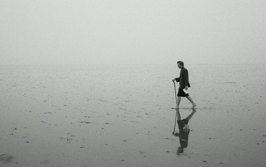
Robert MacFarlane walking the Broomway. Photo: David Quentin
There is a churchyard where 66 people lie buried, all victims of the same killer. But it wasn’t war, plague or murder that took their lives – they all died, implausibly enough, on a footpath.
Where is this deadly right of way? Probably not where you think. It doesn’t wind across a famous bristly ridge like Striding Edge or Crib Goch, or follow a foot-wide ledge across the huge bulk of some vertical crag.
Remarkably, the path in question is entirely flat. And it’s in Essex.
Looking at the Broomway on an Ordnance Survey map, you’d be forgiven for thinking you needed Christ-like water-walking abilities to tackle it. The route starts from a place called Wakering Stairs and appears to shoot directly out into the sea, running parallel with the coast before making landfall again several miles later on the enticingly-named Foulness Island.
Reputed to be “Britain’s deadliest path,” it makes its way over the tidal expanse of Maplin Sands, mudflats on the northern bank of the Thames Estuary. In the past, the route was marked by stakes with bundles of twigs attached resembling witches brooms – hence the name – but they have long since been washed away, making navigation across the monotone environment of the sands a daunting challenge. Walkers who go astray and get caught out when the tide comes back in (which it does at a speed faster than you can run) will drown. The risk of encountering ‘unexploded ordnance’ from Ministry of Defence activities on Foulness if you stray too far from the Broomway route adds an extra frisson to the mix.
Unsurprisingly, the local Public Rights of Way Officer’s advice is to only attempt the Broomway in the company of a local guide. If you decide to attempt it solo, it goes without saying that good navigational ability, heeding local advice and paying careful attention to the tide times are essential if you don’t want to become crab food. For more guidance, see the links below:
The Broomway crosses land under control of the Ministry of Defence and can be closed while military operations are in progress. The MoD’s guidance on the Broomway can be found here.
Local company Nature Break offers guided walks along the Broomway.
For any special instructions or advice that may apply to the Broomway and advice on tidal times, contact the Essex County Council PROW Officer (01268 297545) or HM Coastguard (01255 675518) before attempting it.
The picture here shows author Robert Macfarlane walking the Broomway for a chapter in his book The Old Ways. It was taken by photographer David Quentin. Prints of the walk are available here. For David Quentin’s advice on walking the Broomway, see here.
2. Walk in the footprints of the Yorkshiresaurus
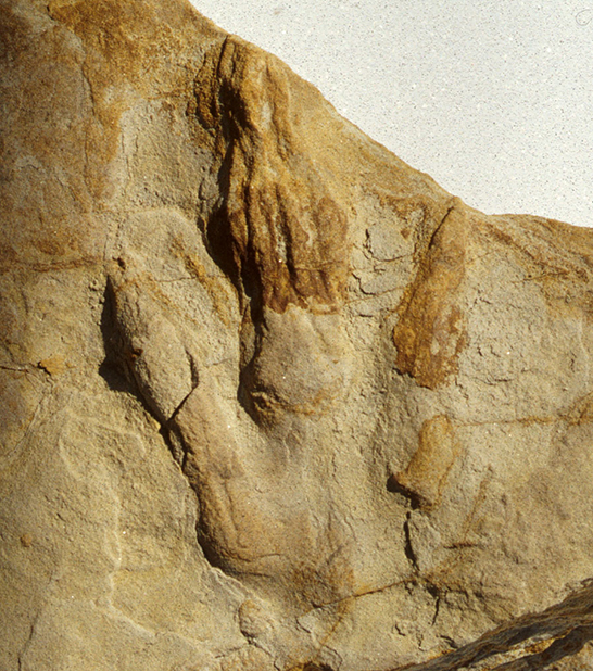
A dinosaur footprint found on the Yorkshire coast. Photo: Tony Bartholomew
If you thought Yorkshire was only ever inhabited by tight-fisted, flat-capped men, brass bands and whippets, you were wrong. Several million years in the past, there were things which were altogether bigger, scalier and a lot more out of place in Last of the Summer Wine.
For evidence, go to the coastline of the county, where lies some of the most ruggedly dramatic coastal scenery in Britain. Watching birdlife whirl above the plunging cliffs of Bempton or exploring the sea-sculpted caves and arches of Flamborough Head are both excellent experiences, but on the stretch of coast between Staithes and Scarborough, biology and geology have combined in extraordinary ways.
You can see rocks from the Jurassic period (150 – 200 million years old) all along the coast, but a closer examination reveals even greater detail from that era. The fossilised impressions of ammonites and lizards can be found preserved with startling vividness, but there are also the impressions of genuine dinosaur footprints, pressed into the mud millions of years ago and preserved to this day by being baked hard in the tropical heat (yes, Yorkshire once experienced a tropical climate.) It’s astonishing to think of them lasting to this day, and adds a surreal dimension to this already-extraordinary stretch of coast. The best places to spot the footprints are Saltwick Bay, Burniston and Scalby Bay.
3. Go seal-spotting in Norfolk
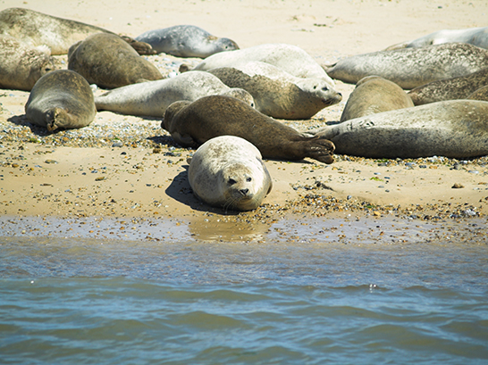
Seals at Blakeney Point
There aren’t that many stretches of beautiful coastline left where wildlife can go about its business without the attention of hordes of beachgoers. Norfolk’s Blakeney Point is one of these rare places.
A National Trust reserve for more than a hundred years, it’s one of the biggest expanses of undeveloped coastline in Europe and its rare combination of sand, shingle, dunes and saltmarsh is home to a staggeringly varied spectrum of plant and animal life. The submerged ruins of a medieval monastery and old dwellings attest to a dynamic and constantly shifting environment, one that has so far resisted much in the way of human habitation.
The reserve’s most striking geographical feature is its three-and-a-half mile long spit of shingle and sand dunes, curving out into the sea like a crooked finger. In 2001, a group of grey seals decided to move in to the tip of this spit, and it has since grown to become one of Britain’s biggest single seal colonies, home to an estimated 500 grey and harbour seals.
Ferry boat trips to see the seals run from Morston Quay but you can of course venture out on to the Point from foot. If you do, be careful to respect access restrictions; this time of year is breeding season for the seals, and certain areas will be out of bounds. Dogs are also a no-no from April 1 to mid-August because of the risk of harm to ground nesting birds. Remember that this is a wildlife kingdom – and it benefits us all to keep it that way.
Visitor information on Blakeney Point from the National Trust
4. Camp in Britain’s weirdest kingdom
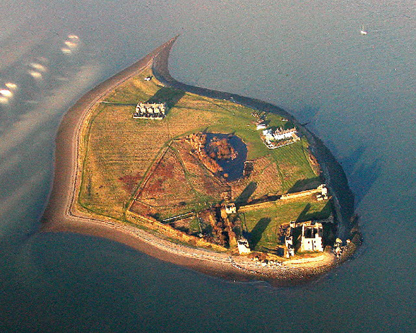
The tiny 'kingdom' of Piel Island. Photo: Simon Ledingham, licensed for reuse under Creative Commons Licence
Attentive news-watchers may have spotted a little story about a certain royal birth recently. But never mind all that – a short distance off the coast of Cumbria lies a tiny island where a measly pauper like you can not only sit on a royal throne but, for a small cost, also receive the honour of a knighthood.
Piel Island (population “four, sometimes five”) lies half a mile off the southern tip of the Furness Peninsula lies and is reached only by a summer-only ferry or a careful walk across the sands from Walney Island. Once there, visitors find a pub, a beach, a smattering of houses, a castle, and not a lot else.
The landlord of the pub, the Ship Inn, boasts the title of ‘The King of Piel’, a tradition stemming from the use in 1487 of the island by Yorkist pretender to the English throne Lionel Simnel and his supporters to mount the last invasion of Britain.
The benevolent King of Piel (who also goes by the name of Steve) also allows visitors to camp anywhere in his kingdom. Pitching up next to the island’s 14th century castle with the sea all around, oystercatchers for company and views over the fells of southern Lakeland is an undeniably atmospheric experience. What’s more, visitors can sit in the King’s throne and be bestowed the title of ‘Knight of Piel’.
The cost for this honour? The noblest thing a person can do, of course – a round of drinks at the bar.
For details, see www.pielisland.co.uk. The ferry to Piel leaves Roa Island daily during the summer season from 11am until 6pm (subject to weather). Camping is available for £5 per tent and must be booked in advance. Before attempting to walk across, consult the Ship Inn first, or alternatively contact local guide and nature expert John Murphy on 01229 473746.
5. Experience the end of the world
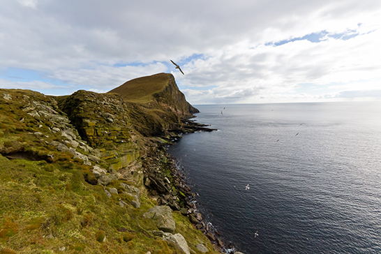
The wild west coast of Foula. Photo: Kevin Serginson
Ancient Roman poet Virgil once wrote of a place called Ultima Thule, a land in the cold far north believed to be the very end of the known world. Various places have been postulated as the real-life location of this land, including Scandinavia, Orkney and Iceland, but go to Foula, one of Britain’s most remote inhabited islands, and you’d have every reason to believe this was it.
People (roughly 30) continue to live and thrive on Foula despite the absence of any pubs, shops, or even trees. Hell for some, heaven for others.
On maps, Foula cuts a lonely shape, a single blob of land lying twenty miles west of the Shetland ‘mainland’. Fully exposed to the ravages of the North Atlantic, at its widest Foula is three and a half miles across, but it packs a huge amount of spectacle into its short size.
The huge cliff on the back of Da Kame on the island’s west coast towers 366m/1,200 feet above the sea below, making it Britain’s second highest cliff after Connachair on St Kilda, an even more remote archipelago.
Da Sneck ida Smaallie is smaller in scale but no less impressive in its own way – a 60 metre-deep, two metre-wide cleft formed when a huge block of sandstone slid away from the cliff face, it’s possible (but not really advisable without a guide) to wiggle down its dank base to emerge at a wild and spectacular storm beach underneath towering, geologically-fascinating cliffs hosting teeming bird colonies.
The island is a paradise for birdwatchers and you can expect to see puffins, petrels, divers, glebes, raptors, rails, rakes, gulls and skua (be warned: the skuas in particular can be aggressive in spring, their nesting season.)
Imagine standing on top of the high perch of Da Kame with the crashing Atlantic far below, seabirds fighting the wind above and the knowledge that there is basically nothing between you and the southern tip of Greenland. Never has the end of the world looked so stunning.
For more pictures of Foula see Kevin Serginson’s blog.
For information on how to visit Foula, see the Visit Shetland website.
This article is part of BMC on Foot, a push to raise awareness of the BMC’s work for hill walkers and its stance on a range of topical issues affecting hill walkers. Please help us by completing our hill walking survey.
Want to get into hill walking? The BMC has teamed up with excellent Plas y Brenin centre in Snowdonia to offer a series of Head for the Hills starter courses. A great way to get the skills you need to be confident in the mountains, you get a discount of up to 50% with free transport from Llandudno Railway Station. For more information see here.
« Back