How is CRoW land displayed on Ordnance Survey maps?
Access land
Access land is clearly displayed on the 1:25,000 series Explorer Maps as a yellow tint surrounded by a narrow orange border.
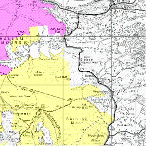
This yellow colouring is also used to denote access land under other agreements, e.g. land owned by the National Trust, Forestry Commission, Woodland Trust and National Park Authorities. This has replaced the previous marking of a thin purple line surrounding access land.
Excepted land
Some land mapped as access land is in fact excepted land, which is land that the new rights under CRoW will not apply to. This includes very obvious cases such as golf courses, aerodromes, racecourses or quarries. Local signs will very often indicate where these areas are.
Restricted land
Access to CRoW access land may sometimes be closed or restricted. Landowners and occupiers have the discretion to suspend or restrict the new access rights for 28 days each year, for any reason. They may also apply for long-term closures, where necessary for land management, safety or fire prevention reasons.
Dedicated land
Section 16 of the CRoW Act, allows private landowners to dedicate their land. Dedication gives the public the same statutory right of access for open-air recreation on foot as other CRoW land. When dedicated land becomes access land (6 months after the dedication agreement has been signed) it is shown on these maps in yellow as access land. The BMC have dedicated their land for climbing.

Access information points are shown by a circular orange 'i' symbol and boundaries of National Parks now appear as a purple dashed line.
For more information on countryside access and restrictions, including on-line maps, visit http://www.countrysideaccess.gov.uk/
« Back
This article has been read
740
times
TAGS
Click on the tags to explore more